Photo:
Wegge, Bjørn
/
Anno Musea i Nord-Østerdalen
(In Copyright)
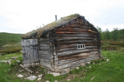
Sluskebu
Kartref.: 41989.86015 (GPS), 1519 II
Beliggenhet: Ved den gamle Grimsdalsgruva. Dagbruddet ligger hele lia nedover fra ca 75 meter SØ for bua.
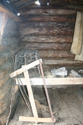
Mål (innvendig): Ca 3,0 x 3,0 meter ( ...
Kartref.: 41989.86015 (GPS), 1519 II
Beliggenhet: Ved den gamle Grimsdalsgruva. Dagbruddet ligger hele lia nedover fra ca 75 meter SØ for bua.
Mål (innvendig): Ca 3,0 x 3,0 meter (utv.: 4,2 x 4,2)
Annet: Dette er en gammel bu som ble restaurert av speiderne i Folldal under ledelse av Morten Berle i 1976-77. Opprinnelig fra gruvedrifta her i årene 1783-88. Se egen rapport som ligger i bua. Tilsv. rapport oppbevares også av Folldal fjellstyre. Bua er registrert på Dovre fjellstyre som også har ansvaret for vedlikeholdet.
Grete og jeg besøkte bua 3. juni 2001.
Foto: Ja. Side 151 + dig. (hytter og buer)


Add a comment or suggest edits
To publish a public comment on the object, select «Leave a comment». To send an inquiry directly to the museum, select «Send an inquiry».