Tømmerfløting – såkalt «brøtning» – like nedenfor Sagfossen i elva Fulldøla i Notodden kommune i Øst-Telemark. Fotografiet viser hvordan strømmen i elva, som endrer retning nedenf ...
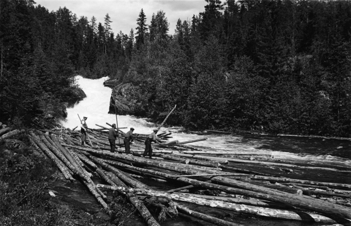
Tømmerfløting – såkalt «brøtning» – like nedenfor Sagfossen i elva Fulldøla i Notodden kommune i Øst-Telemark. Fotografiet viser hvordan strømmen i elva, som endrer retning nedenfor fossen, presset tømmeret opp på ei grunne i en yttersving i elveløpet. Fire karer med fløterhaker arbeidet med haker for å skyve stokkene ut i det strømmende vannet igjen. Til venstre i bildeflata gikk den nevnte fossen kvitskummende over en bergskrent. Langs elvefaret vokste det lauvskog, i det grunne og tørrlendte jordsmonnet bakenfor er det barskogen, og særlig furua, som dominerer vegetasjonsbildet.
Fulldøla kommer fra innsjøen Folljsø eller Follsjå, ei drøy mil nord for kommunesenteret Notordden. Etter cirka 2,5 kilometer renner Fulldøla ut i den større elva Tinnåa eller Tinne, som renner videre nedover mot Notodden sentrum og Heddalsvatnet. Ved Fulldølas utløp av Follsjø var det en solid, gråsteinsmurt reguleringsdam, Umiddelbart nedenfor denne dammen lå Høgefossen med sitt trange juv, noe som førte til at det ble bygd renne for fløtingstømmeret. Sagfossen, som vi ser på dette fotografiet, var mindre, og dermed noe enklere å få fløtingstømmeret gjennom. Nedenfor Sagfossen skulle tømmeret passere Hestøyjuvene og en del stryk nedover mot Makhøl, før det nådde hovedvassdraget. Til tross for dette oppfattet ledelsen i Skiensvassdragets Fellesfløtingsforening Fulldøla som «en meget god fløtningselv, hvor en rekke skjermer og forbygninger hindrer tømmeret i haugdannelse. Brekkasje av tømmer forekommer nesten ikke.» Denne kommentaren er trykt ved kartblad nr. 7 i en serie fløtingskart som Skiensvassdragets Fellesfløtining fikk mangfoldiggjort i hefter i 1940-åra.
Title«Brøtning Fulldøla 16/6-38 Sagfos.» (Innskrift på kvit ytterkant av fotografisk kopi)Original
Dette fotografiet ble funnet i ei mappe i Skiensvassdragets Fellesfløtningsforenings arkiv som inneholdt illustrasjoner til Einar Østvedts bok «Fløtning i Telemark gjennom 300 år», utgitt i 1963 som jubileumsbok for nevnte organisasjon. Norsk Skogmuseums arkivar, Christer Nilsson, la mappa til side fordi han antok at det kunne være aktuelt å gjenbruke noen av motivene som illustrasjoner til det nye manuskriptet museet arbeider med om fløtinga i dette vassdraget. Dessverre viste det seg at mesteparten av materialet i mappa var rastrerte kopier, som ikke er spesielt godt egnet som utgangspunkt for moderne trykking. De fotografiske originalene som lå i mappa ble registrerte ved årsskiftet 2013-2014.

")

Add a comment or suggest edits
To publish a public comment on the object, select «Leave a comment». To send an inquiry directly to the museum, select «Send an inquiry».