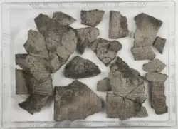
aboutTo skår fra minst ett leirkar, hvorav et hankefragment. Hanken er jevn med runde kanter og en svak vertikal forsenkning sendtralt i hankens lengderetning.Begge skårene er av et rødt, finmagret gods, der hankegodset er dekket av en blank gjennomsiktig glasur.
Arkeologisk utgravning av produksjonsspor og bosetningsspor. Lokaliteten ble først registrert av Buskerud fylkeskommune i 2005. Undersøkelsesområdet lå i dyrket mark som hellet svakt mot S. Jordet avgrenses av boligtomter mot S og V og av bygningene på Frydenlund gård i Ø. Lokaliteten deles i to områder av noen store trær i den østre delen. Ø for trærne ble kun et lite felt åpnet og strukturene viste svært høy grad av senere forstyrrelser og ble derfor ikke prioritert. Ca 250 m mot NØ ligger det to gravhauger i et inngjerdet skogholt. Foto fra undersøkelsen er nummerert cf33742.
C56371 omfatter prøver og funn fra et produskjonsområde med tre produksjonsenheter S115, S127 og S131, og tilhørende grøfter og nedgravninger. Et av anleggene ligger alene innenfor doble grøfter, de to andre anleggene ligger innenfor samme grøft. C-nummeret er organisert slik at funn og prøver fra hvert enkelt anlegg er katalogisert sammen. Funn og prøver fra tilhørende grøfter og mindre anlegg kommer til sist.